50 & 100 MILE COURSES
50 MILE COURSE
This is an out and back course. The course goes up Mount Werner, and then goes right to Rabbit Ears before turning around. It doesn’t get any prettier than that. We think right now it’s just about exactly 50 miles – we ain’t making it longer so you think it’s harder. It’s hard enough the way it is.
SECTION 1 — APPROXIMATELY 6.4 MILES
Starting on the north side of the ski area base near Torian Plum ascend Zig- Zag hiking trail to Forest Service Road 321.1 (Why Not Rd). Continue on FS 321.1 past Rainbow Saddle, past Four Points Lodge, and to the top of Storm Peak and the Mount Werner Aid Station. This amounts to an elevation gain of over 3,500 feet in approximately 6.4 miles! Nice work!
SECTION 2 — APPROXIMATELY 6.4 MILES
From the Mt. Werner aid station join Mountain View Trail (FS Trail 1032). Descend the ridge off Mt. Werner with beautiful views of the meadows of Hogan Park to the south and the rocky peaks of the Zirkel Wilderness to the north. This is single track. A short steep descent at the end of the Mountain View Trail will bring you to a trail junction with the Fish Creek Falls Trail (FS Trail 1102). Take a right onto 1102 (heading east). You will quickly arrive at Long Lake. Rounding the north shore of Long Lake to the Long Lake Aid Station.
SECTION 3 — APPROXIMATELY 5.2 MILES
From the Long Lake aid station continue east along the Fish Creek Falls Trail for approximately 1.3 miles to the four way intersection with the Wyoming Trail (FS Trail 1101). Take a right (heading south) on the Wyoming Trail. Another beautiful section of trail awaits. As you run south through open meadows and old growth spruce, fir, and pine forests, keep an eye out for Lake Elmo. Stay straight through the junction with Lost Lake and you will quickly come upon Fishhook Lake. Much like Mountain View, this is rolling singletrack. A quick descent down the Fishhook drainage will lead to a modest climb up to the Base Camp Trailhead Aid Station.
SECTION 4 — APPROXIMATELY 3.9 MILES
From the Base Camp aid station head southeast along the Base Camp Road (FS Road 311) for about 1/2 mile to the junction with the Wyoming Trail (FS Trail 1101). This right hand turn on 1101 will be well marked but please don’t miss it. Follow the 1101 trail to a short, steep descent to a stream crossing. Cross the stream, continue along the 1101, and look out for Dumont Lake below you. The trail follows an old ditch above the lake for almost a mile until you come upon the Dumont Campground. There is a short section of dirt road on the outskirts of the campground. Look out for a hiker sign on your left, again this will be well marked. Take this left, and follow to the Dumont Lake Aid Station.
SECTION 5 — APPROXIMATELY 5.4 MILES
From the Dumont aid station head to Grizzly Creek Road (FS Road 291). Follow this rough jeep road as it climbs steadily uphill to the base of the Rabbit Ears. At the end of this road you can literally reach out and touch them. A volunteer will be at the turnaround to punch your bib or hand you a card, otherwise there is no aid here, other than the terrific views of the Gore Range, Rawahs, Flattops, and Rabbit Ears Pass area. Catch your breath, turn around, and pound back down to the Dumont Aid Station and return your card. THERE IS A 2:30 PM CUTOFF TO GET BACK TO DUMONT!
SECTION 6 — APPROXIMATELY 3.9 MILES
This is the reverse of Section 4. Follow the 1101 from Dumont along the lake back up to the Base Camp Road (311). Take a left onto Base Camp Road and follow it for about a half mile back to the Base Camp Aid Station. THERE IS A 4 PM Cutoff!
SECTION 7 — APPROXIMATELY 5.2 MILES
This is the reverse of Section 3. Follow the 1101 out of Base Camp down to the Fishhook drainage, then climb back up to Fishhook Lake. Go straight through the junction for Lost Lake, then take a left at the four way intersection with the Fish Creek Falls Trail (FS Trail 1102). Follow this trail for 1.3 miles back to the Long Lake Aid Station. THERE IS A 5:30 CUTOFF.
SECTION 8 — APPROXIMATELY 6.4 MILES
This is the reverse of Section 2. Follow Fish Creek Falls Trail (FS Trail 1102) out of the aid station back along the shores of Long Lake. From the aid station it is 0.8 miles to the trail junction with the Mountain View Trail (FS Trail 1032). Take a left onto the Mountain View Trail, and follow it as it climbs back up the ridge to the Mount Werner Aid Station at the top of the Steamboat Ski area. THERE IS A 7:45 PM CUTOFF!
SECTION 9 — APPROXIMATELY 6.4 MILES
From the top of the ski area, follow the Storm Peak Challenge trail (rough two track) back down to the Four Points Lodge, Rainbow Saddle, and eventually the Why Not access road. Why Not will graciously take you back down to the base of the ski area, the finish line, food and beer.
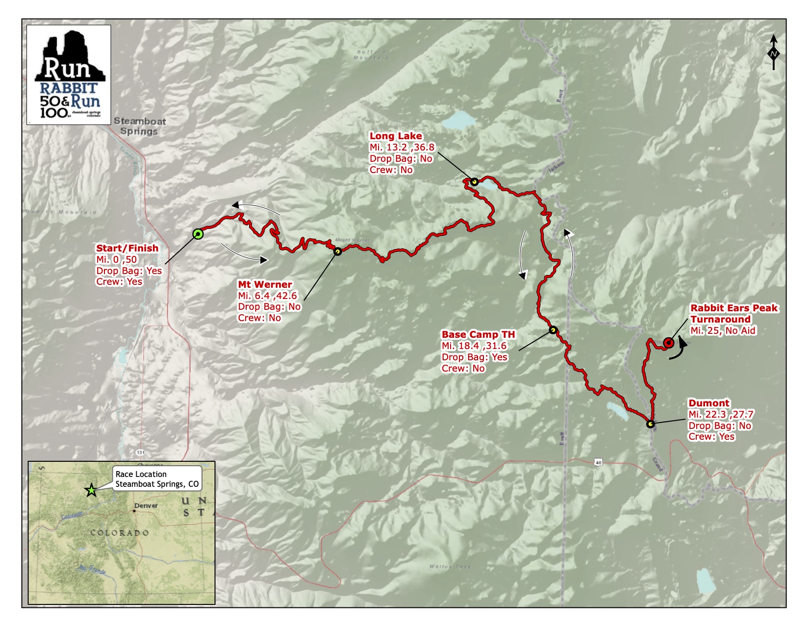
Click map to view course section maps
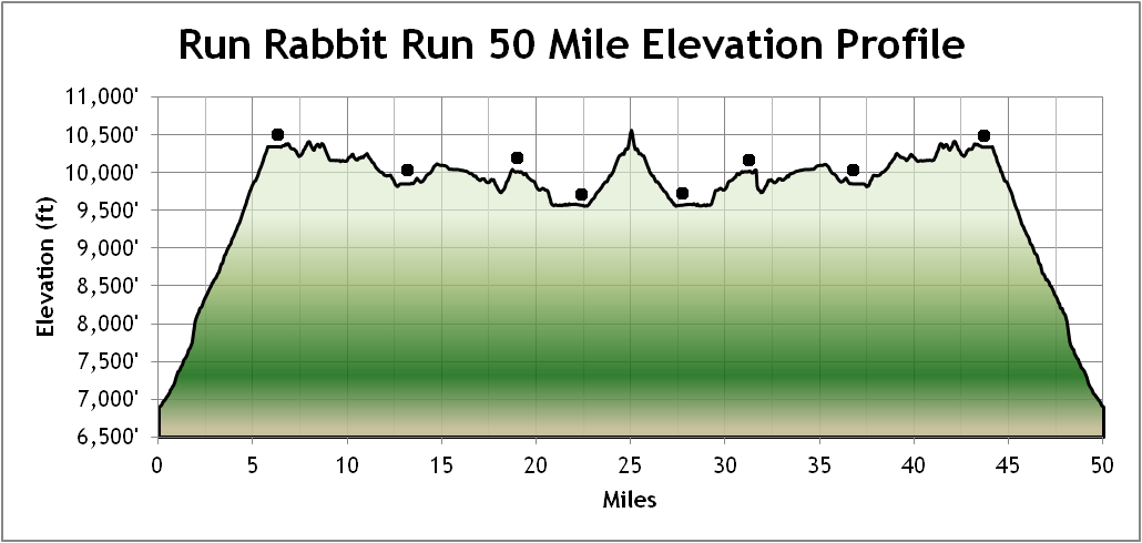
Click profile to view larger image

100 MILE COURSE
SECTION 1 — APPROXIMATELY 5.3 MILES.
Begin at the base of the ski area. Proceed steeply up, up, up – the precise course will depend on construction. We will use the most direct route possible (we will have this well marked). This is not the same route as the Run Rabbit Run 50, but will be steeper and more challenging – why the hare not? – you are ONE HUNDRED MILERS! Join the Chisholm Trail to Four Points Lodge. Take Storm Peak Challenge Trail to the top of the Mount Werner Aid Station. No drop bags or crew access. THERE IS A 3;30 PM CUTOFF.
Begin at the base of the ski area. Proceed steeply up, up, up – the precise course will depend on construction. We will use the most direct route possible (we will have this well marked). This is not the same route as the Run Rabbit Run 50, but will be steeper and more challenging – why the hare not? – you are ONE HUNDRED MILERS! Join the Chisholm Trail to Four Points Lodge. Take Storm Peak Challenge Trail to the top of the Mount Werner Aid Station. No drop bags or crew access. THERE IS A 3;30 PM CUTOFF.
SECTION 2 — APPROXIMATELY 12.3 MILES.
From the Mt. Werner Aid Station join Mountain View Trail (FS Trail 1032). Descend the ridge off Mt. Werner with nice views of the meadows of Hogan Park to the south and the peaks of the Zirkel Wilderness to the north. This is beautiful single track, some of the nicest in Colorado, with short, challenging climbs and descents. After approximately 6.4 miles, you will reach the trail junction with the Fish Creek Falls Trail (FS Trail 1102). Take a LEFT onto the Fish Creek Falls Trail. Shortly after joining Fish Creek trail, you will cross a creek and then run along a stream. If you have a filter and need to replenish water this is the place to do it on this long section. No way can you folks can come all the way to Steamboat and not see beautiful Fish Creek Falls Trail, so go down, down, down through the canyon. The trail can be very rough and rocky and steep (over 25% gradient) in places but so what? – YOU’RE HUNDRED MILERS! (Seriously: Use caution. Your chances of winning, or of finishing, will be significantly compromised should you suffer broken or mangled limbs, or worse). And who cares if you get a little wet! Anyway, it’s early, and you’re feeling pretty fresh, aren’t you? Eventually you’ll get to the trailhead and the Fish Creek Falls Aid Station and the happy face of Russ Garrity. Crew access is permitted only via bike or foot. REPEAT: NO CREW PARKING AT THE TRAILHEAD! NADA! AND NO DRIVING THERE EITHER! OUR FOREST SERVICE PERMIT DEPENDS ON IT! THERE IS A 6 PM CUTOFF HERE!
SECTION 3 — APPROXIMATELY 6.6 MILES.
Yeah, it was really beautiful, but whose idea was it to see that durn Fish Creek Falls Trail anyway, because, having seen it going down, now you gotta go back up it, and darn, it’s long and pretty nasty! Turn around, cursing us beneath your breaths, and go back the way you came – up, up, up. But heck, you’re still pretty fresh – aren’t you? AREN’T YOU?? Please be aware that this is one of the only sections on the course where you are likely to meet other runners ascending or descending the course, and while the trail is not especially narrow, watch out for each other. Go past the junction where you turned down and follow the signs to Long Lake Aid Station and the smiling face of Karl Meltzer. Why is he smiling? Because he isn’t running this durn thing! And then be nice to those folks at the aid station. They’ll feed you and give you drink. Fresh horses! More whiskey! It’s going to start getting real!
SECTION 4 — APPROXIMATELY 5.8 MILES.
From the Long Lake Aid Station signs and flagging will direct you to the Continental Divide Road (310) which you will take to the Summit Aid Station. This is a rolling dirt road with some pretty views. There’s lots more up than down. There’s only one significant junction on this road – veer RIGHT. Continue on the road past Fish Creek Reservoir. Make your way to the Summit Aid Station and Tara Streeb. You will have your drop bags here. New for 2025 – you may have crew access here. However, absolutely no crew vehicles on Buffalo Pass Road! This section is about 5.8 miles.
SECTION 5 – APPROXIMATELY 14.4 MILES.
Of course you’ve been clever bunnies and turtles and going easy so far, because if you can’t run the next section, you may be in trouble. After leaving Summit Lake Aid continue straight on the road (FR310) past the first intersection to where the road T’s after a parking lot on the left. Turn LEFT onto Buff Pass Road (CR60) and go just over 1 mile where there will be a LEFT turn on a double track road (FR306) which marks the beginning of the Flash of Gold Trail. Continue on this road past a couple of well marked forks to where it merges onto a singletrack trail with beautiful views into the North Fork of Fish Creek. 4.2 miles or so from Summit will take you to Billy’s Rabbit Hole Aid Station, and Billy and Amanda Grimes. This is a minimal aid station. Be sure to stock up on nutrition and snacks to prepare for this 10.2 mile beautiful descent through majestic Aspen Groves. NOTE there are 2 sections where Flash of Gold merges onto 2-track powerline roads, each only ~0.5mi. When on these roads be ready for a turn. Proceed down Flash of Gold, cross the upper spring creek bridge and veer left on Flash of Gold past the BTR connector intersection shortly after. You now are approx. 5mi out from Dry Lake Aid Station. Eventually bottom out at a creek crossing where a short bushwack-cutoff (on your right after the small bridge) takes you up to Buff Pass Road. Turn left and continue the short ways until you reach the Dry Lake Aid Station and the happy faces of Anne Lance and Jennifer Van Cleave. Just follow the course markings! YOU MAY PICK UP A PACER HERE BUT NO PARKING AT DRY LAKE! HAVE A CREW MEMBER DROP OFF YOUR PACER AND LEAVE THE AID STATION!
SECTION 6 — APPROXIMATELY 6.2 MILES.
After you’ve rejuvenated yourself, an aid station volunteer will point you down Spring Creek Trail, which is very nice single track, through some very pretty and interesting flora, with wildflowers and jungle-like plants with big leaves – lots of which looks like nice munchies for turtles and rabbits. But don’t stop – you’re going down, mostly, anyway. Fifteen bridges take you across bubbling Spring Creek – there’s a peacefulness here – it’s quite lovely! Near the bottom of the trail you might get a little wet, but after about 5-½ pleasant miles you emerge at Spring Creek Trail Head and Amethyst Road. ALL RUNNERS MAY PICK UP A PACER HERE! Cross the road and join the trail to your left and follow this trail through town and emerge at the intersection of Fish Creek Falls Road and Third Street. Pay attention as you will be crossing Lincoln (the main street through town) and we cannot stop traffic. Signs will direct you the short ways to the Olympian Hall Aid Station where you can see Bronwyn Ritter dance. If you’re a Tortoise, you can pick up another pacer here. If you’re a Hare, your pacer needs to stop. You’re just about half way! THERE IS A 2:230 AM CUTOFF HERE!
SECTION 7 – APPROXIMATELY 12.7 MILES.
Hey, welcome to beautiful Emerald Mountain! Well, okay, another climb. Signs and volunteers will direct you to Blackmere. Take Blackmere Drive up, up, up. Why not? Heck, YOU ARE ONE HUNDRED MILE RUNNERS! Continue up Blackmere turning left uphill on Little Moab to the Lane of Pain (ouch!) to the steeply rolling Ridge Road where we will try and have a minimal aid station. Markings will direct you to turn right on Stairway to Heaven, descend and turn right on Blair Witch then turn right on to Quarry Mountain Trail, which will take you back to the minimal Lane of Pain Aid Station. From there take Morning Gloria and descend to Lupine then turn left on to Emerald Meadows to the Stables; turn left, pass the Yurt and then back to Olympian Hall Aid Station. What a nice tour of some of Steamboat’s prettiest trails! Umm, just one thing – most of you will be doing much of this in the dark. Please be aware that this section teems with game. BE CAREFUL OF BEARS, PARTICULARLY MOMMA BEARS WITH CUBS! WATCH OUT FOR MOUNTAIN LIONS! THIS IS NOT A PETTING ZOO! THERE IS A 7:45 AM CUTOFF HERE!
SECTION 8 — APPROXIMATELY 6.2 MILES.
This section is the reverse of Section 7 to the Dry Lake Aid Station. Again, everyone, Hares too, can have a pacer from Olympian Hall to Spring Creek Trailhead. Please pay attention. You will be crossing through the center of town and there will be a traffic light when you cross Lincoln (Steamboat’s main street)! If you have a pacer, they can guide you through; And no headphones please until you get on Spring Creek Falls Trail. Go up, up, up to the Dry Lake Aid Station, climbing the 5.5 miles of lovely Spring Creek Trail to the Dry Lake Aid Station, but as tired as you are, we don’t blame you for not noticing how pretty it is. Say hello, grunt a bit, thank the volunteers, and maybe change pacers. But be sure to ask them: Are you ready for this? Because you’re going with me the rest of the way, and it ain’t easy! You are now at about mile 70. THERE IS A 10 AM CUTOFF!

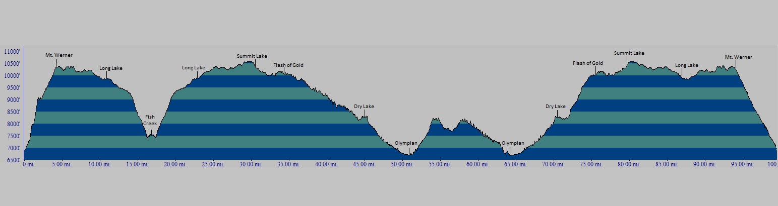

SECTION 9 — APPROXIMATELY 10.8 MILES.
Gather yourself, load up on food and liquids, get out of the Dry Lake Aid Station, and join the Ditch Trail that contours above the Soda Creek Drainage, turning right at the junction with Grouse Trail (at about 1.3 miles). You’re going up, up, up. Pay attention to white painted dash marks and cairns that mark the sections of trail that cross over large sections of granite. Also note that sections of this trail are very steep and there are blind spots for descending mountain bikers who may find it difficult to stop should they encounter you. Use caution here and continue up the trail; when the trail returns to rock, continue to follow the cairns and dash marks. At about 4.5 miles you will reach Buff Pass Road; turn LEFT on Buff Pass Road for a very short ways (less than .2 miles). Markings will direct you to Flash of Gold where you will turn LEFT. Billy’s Rabbit Hole will be about 6.3 miles from Dry Lake. Enjoy the thin air. After approximately 4.5 miles you will reach the Summit Lake Aid Station. You can have a drop bag here. New for 2025 – you may have crew access and change pacers. But absolutely no crew vehicles or crew aid on Buffalo Pass Road! THERE IS A 3 PM CUTOFF HERE!
SECTION 10 — APPROXIMATELY 8.6 MILES.
From the Summit Lake Aid Station head east until the junction with the Wyoming Trail (FS Trail 1101), also known as the Continental Divide National Scenic Trail. Go south on the Wyoming Trail. Stay on the rolling trail for about 6 miles, passing through high elevation forests and meadows, much of at two miles elevation. You will, after about 5 or so miles, hit elevation 10,557, the nominal high point of the course. Keep breathing. Keep moving. No one has ever finished a one-hundred miler standing still, or, worse yet, lying on the side of the trail. Make your way to the four-way junction with the Percy Trail and turn right (west) on to Fish Creek Falls Trail, (FS Trail 1102). Go another 1.7 miles or so to the Long Lake Aid Station. THERE IS A 5:30 CUTOFF HERE!
SECTION 11 — APPROXIMATELY 6.4 MILES.
Drag yourself out of the aid station, continue on, veering left when you reach the junction with the Mountain View Trail (FS Trail 1032) and that beautiful Mountain View single track. You may see some of our Run Rabbit Run 50 mile bunnies out there and we’re sure they’ll cheer you on. Kind of forgot about that little climb up to the Mt. Werner Aid Station? Fuhgettaboutit! You’re tough! You’re a ONE HUNDRED MILER, and once you get to Mount Werner Aid Station, it’s all downhill from there! MAKE THAT 7:45 CUTOFF!
SECTION 12 — APPROXIMATELY 6.4 MILES.
This is it! You’re almost done! It’s about 6.4 downhill miles to the finish, the same route as the Run Rabbit Run 50, to right down to the bottom of the ski basin. Down Storm Peak Challenge, past Four Points Lodge, to the Why Not Road, to some single track and then (what? – you’re going to make us cross that little stream?) to the finish. And to beer and food. And remember: The clock doesn’t stop until the Designated Hugger gives you the hug! Okay. COVID. We’ll take an elbow bump.
Congratulations. You’ve done an amazing thing. About 8 miles paved, about 86 miles of trails and the rest rough jeep roads. Figure about 101.5 miles, 20,391 ft. ascent and 20,391 ft. descent.
We’re not exactly pulling a rabbit out of a hat, but we won’t pretend we can estimate any better than that.